| Home | | | About | | | Partners | | | Help | | |
|
|
|
||||||||||||||||||||||||||||||||||||||||||||||||||||||||||||||||||||||||||||||||||||||||||||||||||||||||||||||||||||||||||||||||||||||||||||||||||||||||||||||||||||||||||||||||||||
| Dear Visitor! If you want to master the site and to use maps effectively, use the Help System on the left. If you have not found the answer to your question, write to us. |
| Map Is Not Visible The map is not visible in the following cases: 1. The map is not visible in the "Professional" view. Cause: Java Virtual Machine is not installed on your computer. Actions: Enter the "Standard" view or install Java Virtual Machine. Install. 2. It's not for the first time you refer to the maps at our site in the "Professional" view, and at some moment the map and/or interface became invisible. Cause: We had a new WebMap cartographic server version installed at our site, and your browser keeps to use its cache information. Actions: Clear the browser cache. To do it, if you use MS Internet Explorer 5.0, enter the TOOLS menu - BROWSER PROPERTIES - GENERAL tab, and click the button DELETE FILES under TEMPORARY INTERNET FILES label. 3. To our regret it is not possible to look through the maps in the "Professional" view at our site, if you have Netscape Navigator and enter Internet via proxy-server. In this case either you can look through the maps in the "Standard" view or install the Microsoft Internet Explorer browser. |
|
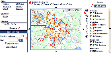
Map View Modes You are offered two map view interfaces ad liberum: STANDARD and PROFESSIONAL. You can access most services with both interfaces. There is slight difference in the operation of some tools. STANDARD View Mode - it is made with the technology Java-Script. It's very easy to use. It is offered by default after site downloading for the first time. PROFESSIONAL View Mode - it is made with the technology Java-Applet. To look through the maps in this view, Java Virtual Machine is not installed at your computer. Java Virtual Machine is to be installed at your computer. The interface to work with a map in the "Professional" view is similar to geoinformation program and graphic editor interfaces. For instance, you can zoom in or out a map by setting a rectangular area in the map window. If you have not Java Virtual Machine installed, you can install it by yourself. It's free of charge. Install. On any site page there is a map view mode switch: When you switch to a map, the interface of the view mode selected by you is set. You can also directly switch to the other map view mode, when you a working with a map. After it this other view mode shows the same map with the same customizations. At the next (not the first) www.eAtlas.ru site downloading, you will be offered the map view mode you used last. |
|
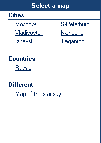
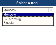
Map Selection You can select a map from any site page. The map list is on the left of the site under "Select Map". The map list can be presented in two ways: as an unfolded list or a drop-out list.
|
|
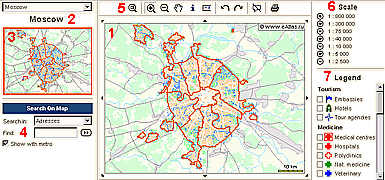
Map Size Map window size can be either SMALL or LARGE. The sizes are adjusted to monitor resolutions. The map window size "Small" is optimal for monitors with the 800х600 resolution. The map window size "Large" is optimal for monitors with the 1024х768 resolution. A map to be downloaded will be opened in the window of the size corresponding your monitor resolution. You can change the map window size by yourself: For instance, if you have a 1024х768 monitor, but your Internet access speed is not high, you can set the map window size smaller to reduce the downloading time. |
General
|
|
Scale Change "Standard" View Mode 1. Select one of the switches Place the cursor in the map window and press the mouse left button. The map image will be twice/half as large and the map place you have pointed will be its center. 2. Click the image 3. Scale levels. Pressing |
|
Scale Change "Professional" View Mode 1. Select - Place the cursor in the map window and press the mouse left button. The map image will be twice/half as large and the map place you have pointed will be its center. - Place the cursor in the map window. Having the mouse left button pressed, draw a rectangle. When zooming in, the map image inside the rectangle will fill the whole map window. When zooming out, the map image will be decreased to the size of the rectangle. 2. Click the button in the toolbar 3. Scale levels. |
|
Picture Shift "Standard" View Mode 1. Select the switch Place the cursor in the map window and press the mouse left button. The map place you have pointed will be the center of the window with map. 2. Click the arrows 3. Using "Navigator" window. The red squire in the "Navigator" window corresponds to the map area displayed in the window map. If you click a new point in the "Navigator" window, this point will be the center of the map window, the picture scale being the same. "Professional" View Mode 1. Select 2. Click the arrows 3. Using "Navigator" window. The red squire in the "Navigator" window corresponds to the map area displayed in the window map. If you click a new point in the "Navigator" window, this point will be the center of the map window, the picture scale being the same. |
|
Distance Measuring "Standard" View Mode Select the switch Place the cursor in the map window and click two or more map points, between which you want to measure distance, with the mouse left button. The clicked points will light in the red colour, and the length of the segment or polygonal path set by you will be shown in the new window "Ruler" having opened. You can proceed with setting points on the map, the "Ruler" window showing the total length of the whole polygonal path. To close measuring mode, press the button "Close" in the window "Ruler" or select another switch in the browser showing the map, the "Ruler" window having closed, and the red points corresponding to the nodes of the polygonal path going out. "Professional" View Mode Select To close measuring mode, double click with the mouth left button in the map window or select another tool. Clicking the button (X) closes the "Ruler" window. |
|
Help on Object Select the switch ("Standard" mode) or Place the cursor on the object of interest to you in the map window, and press the mouse left button. The help on the object will appear in the new window having appeared. It usually contains the object name, its type, additional characteristics. In the help window may be a reference "Details". After having pressed it, you will see a window with details on the object from the site eAtlas or another site. |
|
Legend Legend is a list of conventional signs, with which objects are denoted on a map. The legend is situated to the right of the map window. If a part of it can only be placed in the browser window, then a scroll bar will appear to the left of it. Each object type (a map layer) has its own conventional sign. Near to a conventional sign there is a checkbox. A tick in it means that the objects of this type are visible on the map. To remove a layer from the map in the "Standard" mode, you need to clear the checkbox near the corresponding conventional sign and click the button "Refresh Map". To remove a layer from the map in the "Professional" mode, you need to clear the checkbox near the corresponding conventional sign. To add a layer to the map in the "Standard" mode, you need to put a tick near the corresponding conventional sign and click the button "Refresh Map". To add a layer to the map in the "Professional" mode, you need to put a tick near the corresponding conventional sign. For the "Professional" mode only: If a conventional sign is painted in the grey colour, the objects of the corresponding type are not shown on the map in the current scale. |
|
Previous Map View This option is only in the "Professional" Mode. If you click the following buttons on the toolbar The previous/next image will appear in the map window. Each click will move you a step forward/backward. |
|
Searching Object by Name To find an object and display it on the map, you should select the required object type in the field "Search in:", then input first letters of the name or the * (asterisk) sign in the field "Find" and click the button or Point the required object in the appeared window for search, and it will become the center of the map window and be selected with contrasting colour or hatching. |
|
Searching Object by Address (only for town maps) To find a building and display it on the map, you should select "Addresses" in the field "Search in:", then input first letters of the street name or the * (asterisk) sign in the field "Find" and click the button or Indicate the required street in the searching window having appeared. After that a list of all the buildings in the street will appear in the searching window. Indicate the required building in the searching window, and it will become the center in the map window. |
| Legal Information | |
| Copyright © 2000-2007 RESIDENT CONSULTING, Ltd., Resident, Ltd. | |
|
|
|
|
|
||